Introduction
One of my favourite walks is along the Rhossili coastpath from Tears Point to Ramsgrove, where I can also appreciate the geology of the area and the abundance of fossils as I stray down into the coves. I think it’s only fair for me to preface this piece by stating that I am not a Geologist or a Palaeontologist. I had a brief dabble with it as an undergraduate student and I did once study Geology at O and A level in school. For those who remember ‘O’ Level exams, you’ll know it was quite a long time ago…
Geology is the study of rocks, and palaeontology the study of fossils, I know a bit about these things, but if anyone qualified in either field reads the article and would like to send me some corrections, I’ll happily review and include them. Most of the photographs included in this piece are ones which I have taken while walking the cliff path from Tears Point in Fall Bay to Ramsgrove, with a few from outside the immediate area.
Basic Geology of Gower
Most of the rock we see in Gower originates from the geological time period known as Carboniferous, a term used to describe the period from roughly 359 to 299 million years ago, when many of the rich deposits which form coal were made. To try to put the geological timescales into perspective, it is worth visiting this link to the British Geological Survey’s Timechart diagram, which describes the different geological periods and their ages. The oldest known rocks on Earth are around 4500 million years old, so you can see that the Carboniferous Limestone rocks of the Gower are quite young in geological terms! Fossils start to appear in the most recent 12% of Earth’s history – that’s just 540 million years out of 4500.
Other rocks are also present in Gower, notably on Cefn Bryn, which is formed by the red coloured rock known as Old Red Sandstone. Figure 1 shows a geological map of a section through Gower with the Loughor estuary on the left and Cefn Bryn on the right. The rock types are labelled, so it’s possible to see what’s above and below ground, and which rock type forms the surface features seen.

Carboniferous Limestone is soluble (i.e. it slowly dissolves) in rainwater and that makes for complicated landscapes which cause streams to suddenly disappear underground as at Pitton and Kingshall, and for underground aquifers to form. These features are often covered by soil, so we don’t necessarily see the complexity. An example of an exposed limestone plateau is shown in this BBC video, which shows how the surface of the limestone is dissolved away to form channels and crevices over thousands of years.
The origins of rock
There are basically two different types of rock. Sedimentary rock, formed by the deposition of silt, mud, sand etc, in rivers and sea environments, which is then crushed over thousands of years by the build-up of many such layers (called beds). The other type of rock is known as igneous, and perhaps more spectacularly, this is created deep within the Earth. This is rock in a molten state, pushed upwards under pressure into cracks in the Earth’s surface, where it cools and solidifies – or erupts as in volcanoes. You can find out more about rock formation here.
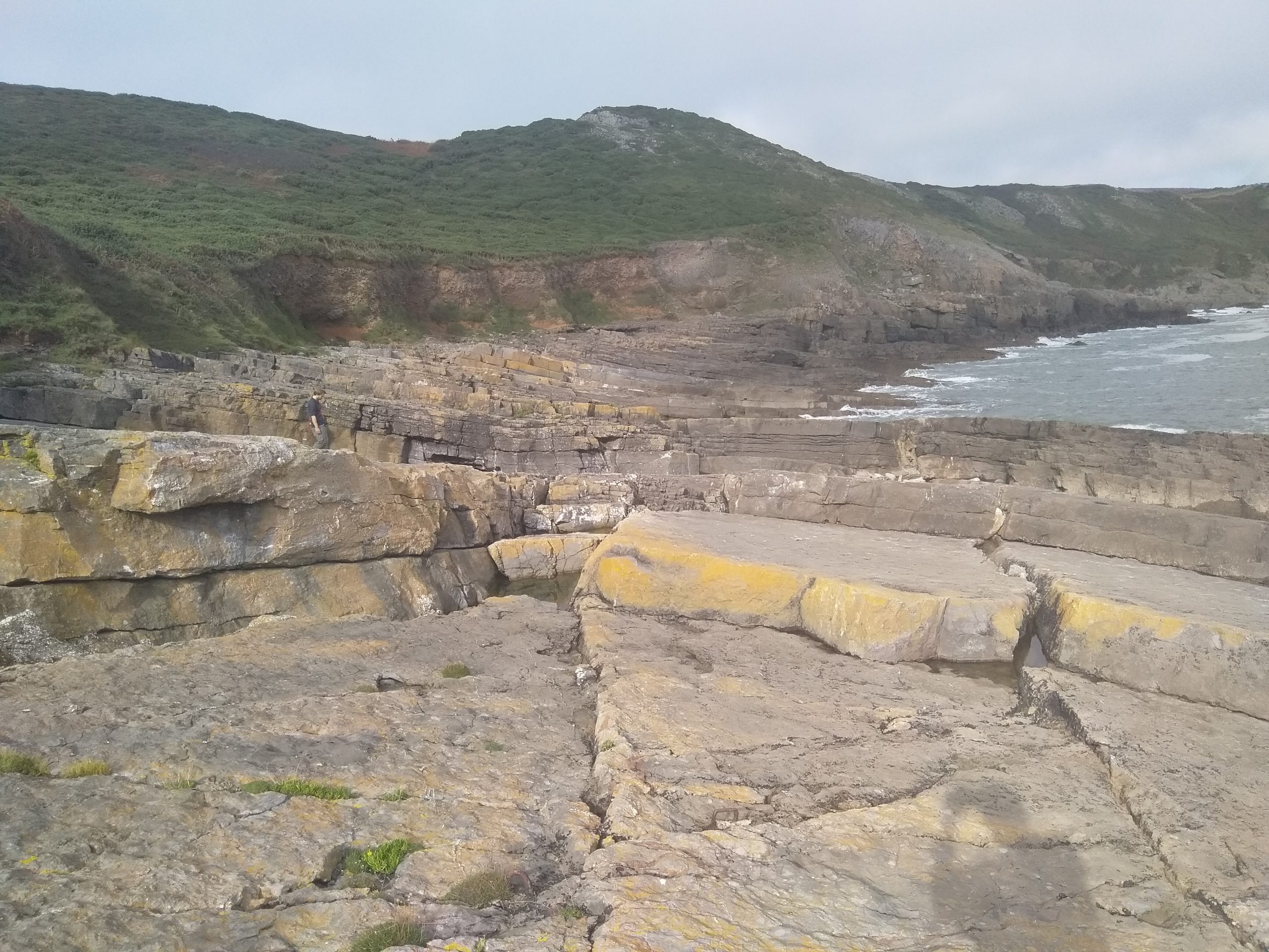
The Carboniferous limestone of Gower is an example of sedimentary rock and this BBC video describes the formation process. The video describes the slabby layered ‘bedding structure’ typical of sedimentary rocks and is displayed well in these images below of Fall Bay, taken from the west end of the bay near Tears Point.


Another interesting and informative BBC video shows the mechanisms by which coastal areas such as Gower are eroded to form bays, headlands and other features we see.
Rock beds are also subject to folding where the Earth’s crust moves to cause compressions or tensions in the rock. Compressions tend to fold the rock as shown here, and tensional forces tend to form cracks, fissures and faults, which you can find out about here.
So what about fossils?
Fossils are the captured remains of flora, fauna and other things, which in the case of fossils found on this stretch of the Gower coast path, have been trapped in sediments and preserved by petrification, which you can find out about here. One of the most spectacular examples of fossils preserved by this method is the Petrified Forest National Park in Arizona. Preservation can take a number of forms (more information here ).

Although people generally think of fossils as the remains of plants and animals, geological structures can be preserved as fossils too and a good example is this image (left) of a fossilised beach which occurs on the coast path between Caerfai Bay and Solva in Pembrokeshire.
Fossils can also take the form of imprints left by animals, such as this Tyranosaurus footprint we saw inTuba City, Arizona (below, left) and perhaps less spectacularly, the photo of fossilised worm burrows from the shore near Ramsgrove.


Fossils on the local coast path
On the section of the path from Tears Point to Ramsgrove, there are fossils visible in the rocks in many places. Near Tears Point, if you stand on the slabby rock beds of Fall Bay shown in the above photos, it’s hard to look at the rock and not see a fossil of some kind. An example of a crinoid stem is shown below.

You might be forgiven for thinking that fossils are an extremely common occurrence, but the opposite is true. The formation of fossils requires very specific conditions, and in practice, these rarely occur. Even when fossils are preserved, movement of the Earth’s crust, rock folding and crushing, and igneous activity can all destroy fossils. So we are quite privileged to see so many fossils in the Carboniferous rocks of the Gower coast. On the coast path, fossils are usually preserved by petrification, where quartz has replaced the calcium carbonate shell material of the once living animal. Quartz is much harder than Carboniferous Limestone, so where the limestone itself has been worn away by wave action, the fossils themselves can be quite well preserved.

The photo left shows a band of fossiliferous rock on the edge of a slab at Fall Bay above the high-water mark. If you zoom in to the image, underneath the right-hand end of the penknife, there’s a Gastropod fossil. To the left are many sections through the stems of stalked Crinoids, which were filter feeding animals (you can see what they looked like here). Gastropods, commonly known as slugs and snails, took many forms and you can see the diversity of forms here.
Another example from the same area, shows a multitude of fossil fragments, mainly sections through rugose corals and crinoid stems Below left). The middle photo shows a crinoid stem and coral section and the photo on the right shows a rugose coral section in more detail. Tears Point is a really good fossil locality, with lots to see!


The four photos above were taken on the seaward edge of Tears Point, where the ground is very steep. I wouldn’t recommend a visit, unless you’re an experienced scrambler, and of course, don’t go on your own.

Moving along the coast to Mewslade Bay, again there are fossils to be seen, but not in the same numbers as at Tears Point. You have to look harder to find examples and particularly at low tide when the sand is washed away, nice sand-washed and glazed examples can be seen. On the left you can see a photo of a pebble found on Mewslade beach – a nice example of a section through a Carboniferous Gastropod.
Leaving Mewslade and heading towards Ramsgrove, at the first gate on the coast path, there is a stone wall leading to a wooden fence above a cove which is only accessible at low tide. If you are a competent scrambler, you can leave the coast path just after this gate and go down to the cove at sea level. DO NOT follow the stone wall in an attempt to get to the cove (see photo below left). The area of cliff near the stone wall/ wooden fence (shown in the photo) is very dangerous, don’t go near that! If you want to go down to the cove, start at the coastpath gate. Walk through the gate and face the sea. On your left is the headland you can see in the photo (bottom right). Walk towards the headland, trending downwards toward sea level and note there is no footpath. Eventually the grassy slopes meet with the rocks and it’s possible to scramble down into the cove. Again I would emphasize, only do this if you are a competent scrambler, experienced in finding safe ways down from the coast path to sea level.


Again, just to note, there’s no path, so the walking is over grass to start, then as you go down to sea level, it’s rocky surfaces. When you get down to sea level in the cove, the fossils shown in the pictures below can be seen by walking out of the cove (sometimes there’s a pool you have to wade through) towards the sea, low down in the rocks on the right. The area of fossiliferous rock covers an area of about 15 metres by 3 metres. If you’re adventurous, the rock beds at sea level in the next cove along (west) contain huge numbers of fossils. If you go to that cove too, watch the tide, but you can escape upwards if you’re a competent scrambler. The images below are a small selection from the cove.


The modern ethical code is to leave fossils in place, just take photos. The successful removal of fossils is a highly specialised skillset needing special tools and advice from a Palaeontologist, so best leave the fossils in place for others to enjoy.
Being able to combine a walk along our beautiful coast path with looking out for fossils, definitely makes Tears Point to Ramsgrove one of my favourite walks!
Pauk Kirk (Pitton)
We live in an Area of Outstanding Natural Beauty and there’s no shortage of lovely walks. Do you have a favourite walk? Is it with a person, a dog, a horse? Or is it somewhere outside the area? Tell us about it! Please get in touch by email (rhossilihwb.cymru@gmail.com) or contact Maggie or Isobel directly and we can chat about how best to share your favourite walk here.
Fascinating post Paul. I’ve noticed a few things that I thought might be fossils on the coastal rocks but not thought any more about it, so this is very useful and, with all the references, definitely a blog to return to.
Where’s that Mewslade pebble now? – it’s a beauty!
Thanks Francis, the Mewslade pebble is on my desk with quite a few other shoreline specimens. By all means call in one day to see it. 🙂 🙂